ニセコ雪崩情報 第98号
Niseko Avalanche Information No.98
Saturday 14/03/2026 土曜日
山麓-1度風よわく降雪わずか モイワ800m-3.2度東北東4.4m アンヌプリ1100m-5.1度北北東6.5m ビレッジ1000m-4.0度北北東10.9m ヒラフ花園1000m-4.6度北9.9m降雪5cm 花園800m-2.8度北3.6m 日本海弁慶岬北東8m 神威岬東北東4m気圧1025hPa波高不明、
千島列島の低気圧から吹く北東風が依然強く標高1000m以上に浅いふきだまりが発達、バックボウルなどの開けた急斜面ではクラスト破壊の浅い表層雪崩が起こる可能性がある。魔法の絨毯と呼ばれるこの雪崩に乗ると高速で谷底に運ばれ硬いデブリに埋められる。各所で全層雪崩の危険が高まっている。特に標高800m以下の各スキー場連絡通路法面、見返り及びモイワボウル、立ち入りが規制されているヒラフスーパーコースでは注意。全層雪崩は亀裂から予測できるが亀裂発生と同時に雪崩れることがある。利用者の事故防止のため主な山頂ゲートは閉じられる。パトロールの意見を聞くこと。春への移行期のこの時期には様々な危険がある。山に入る時は間隔をあけて歩くこと、谷底や斜面下で休憩しないこと、増水し始めた沢への転落に注意、スノーブリッジ下に流されると救助困難、ビーコンとともに8mm/15m程度のショートロープの携行を勧める。立ち入り禁止区域春の滝、湯の沢、モイワアンベツ谷と閉鎖されている水野の沢には絶対に入ってはならない。ルールの尊重を。ガイドやツアーリーダーには安全に対する大きな責任がある。
Moiwa base 6am: -1℃, light wind, trace new snow. Moiwa 800m: -3.2℃, ENE4.4m/s. Annupuri 1100m: -5.1℃, NNE6.5m/s. Village 1000m: -4.0℃, NNE10.9m/s. Hirafu Hanazono 1000m: -4.6℃, N9.9m/s, 5cm new snow. Hanazono 800m: -2.8℃, N3.6m/s. Coastal data: Benkei Cape NE8m/s, Kamui Cape ENE4m/s, 1025hPa, wave n/a.
Strong northeasterly winds blowing from the low-pressure system over the Kuril Islands are causing shallow snowdrifts development above 1000m. Shallow surface avalanches due to crust failure are possible on open, steep slopes like Back Bowl. If caught in these avalanches, sometimes called “magic carpets,” you are carried at high speed to the valley floor and buried in hard debris. The risk of full-depth avalanches is increasing around the mountain. Particular caution is advised on the slopes by run outs between ski resorts below 800m, eg: Mikaeri and Moiwa Bowl, and Hirafu Super Course, where entry is restricted. Full-depth avalanches can be predicted from cracks, but avalanches can occur instantaneously when cracks appear. The main peak gates will be closed to prevent accidents. Please listen to the patrol’s advice. There are many dangers during this transition to spring. When entering the mountains, walk with sufficient distance between your party, do not rest in valley bottoms or at the bottom of possible avalanche slopes. Be careful not to fall into swollen streams, rescue is difficult if you are swept away under a snow bridge. It is recommended to carry a short 8mm x 15m rope along with your beacon. Never enter the restricted areas of Harunotaki, Yunosawa, Moiwa Anbetsu, or the closed Mizunosawa area. Respect the rules. Guides and tour leaders have a great responsibility for safety.
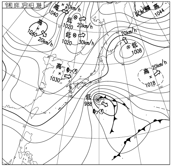
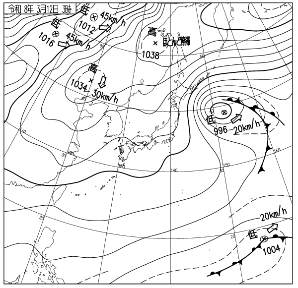
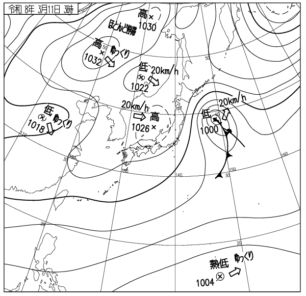
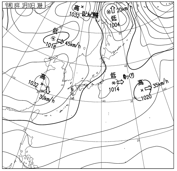
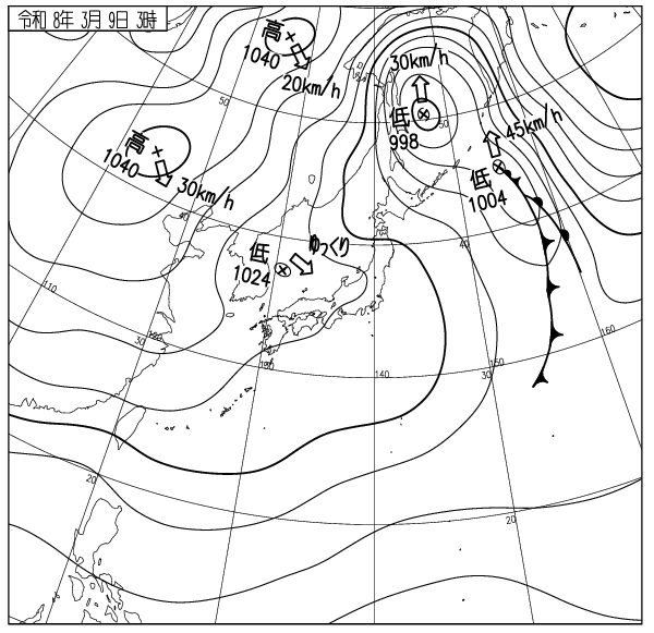
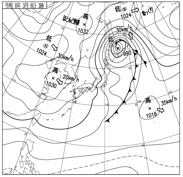
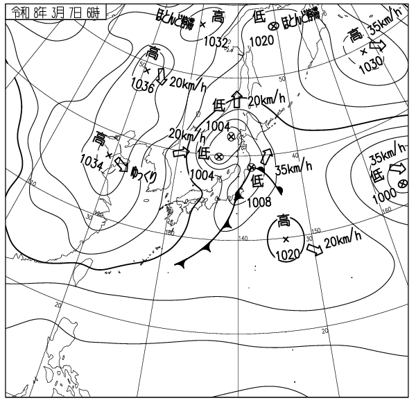
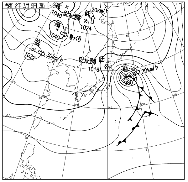
出典 Source:気象庁 JMA website (www.jma.go.jp/bosai/weather_map/)
この情報はコース外滑走の安全を保障する物ではありません This information is not to guarantee the safety of out of bounds riding. ニセコルールを守りましょう Please respect the Niseko Rules. レスキューはコース内が優先されます Inbounds rescue will be prioritised. コース外へは自己責任で Step out of bounds at your own risk.
ニセコ雪崩調査所 Niseko Avalanche Institute