山麓6時+2度積雪30cm モイワ見返り800m-7度南東1.5m降雪視界不良 花園800m-1.4度北3.0m夜半0時北東23m/s突風 日本海弁慶岬北北西5m 神威岬南西7m気圧1012hPa波高1.1m、
未明まで降雪なし、午前6時から低気圧前面降雪、午後には前線通過で山は荒れ模様の見込み。雪は依然少なく圧雪されたコース以外は滑走不能、待つしかない。
寒暖差が大きいため地表付近のシモザラメ化が進んでいる。この層は初冬のニセコに稀に見られ、全層雪崩の原因となる。コース法面や笹地表の急斜面では注意。
事故が最も多い面発生表層雪崩は吹雪など悪天候時に起こりやすい。風雪時に風下側のふきだまり斜面を滑ってはならない。スラブが弱線破断して雪崩を起こす。良い一日を。
Mountain base 6am: +2℃, 30cm snowpack. Moiwa Mikaeri 800m: -7℃, SE1.5m/s, snowing and bad visibility. Hanazono 800m: -1.4℃, N3.0m/s (NE23m/s gusts at midnight). Coastal weather: Benkei cape NNW5m/s, Kamui cape SW7m/s, 1012hPa, 1.1m waves.
No snowfall until predawn, but started to fall around 6am as the next Low Pressure approaches. The Cold Front will pass in the afternoon and the weather is forecasted to deteriorate. The snowpack remains shallow and the slopes are not suitable for skiing except the groomed runs. Patience is required.
Depth hoar is developing with the recent large temperature swing. This is quite unusual for early Winter in Niseko and can potentially be a trigger layer for glide avalanches. Caution is required in steep slopes on the course-sides and/or with bamboo-grass. Surface slab avalanches, which are the cause of most accidents, mostly occur during snowstorms or other bad weather conditions. Leeward slopes with heavy snowdrift deposits should be avoided during strong winds and snowfalls. Weak bonding within the newly formed slabs can easily fail and trigger a slide. Have a nice day.
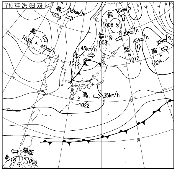
出典 Source:気象庁 Japan Meteorological Agency (www.jma.go.jp/bosai/weather_map/)