Category: なだれ情報

  • ニセコ雪崩情報第20号 Niseko Avalanche Info No.20

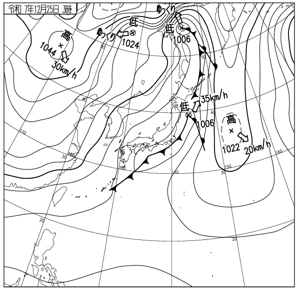
    モイワ山麓6時0度降雪なし モイワ800m-3.7度北北西2.2m 見返り800m-6度北1.1m降雪なし ヒラフ花園1000m-5度風よわく降雪なし凍結 花園800m-2.8度北北西2.1m 日本海弁慶岬北北東6m 神威岬北東2m気圧1012hPa波高0.8m、

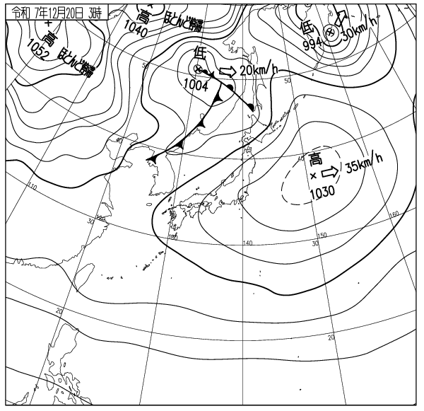
    弱い冬型の気圧配置で寒気流入、降雪はなく海上、山ともにおだやか、降雪なし。雪は堅くアルペン練習には良いがパウダー好きには最低のコンディション。ゲレンデは混んでいる。暴走衝突に注意。

    この雪崩情報は40年前の雪崩事故多発に困り、事故防止のためにやむを得ず始められた。日本海からの吹雪による多量の降雪と、新雪斜面へのリフトアクセスの容易さがニセコに多くの人を集めたが、それが当時の事故多発の背景にはあった。ニセコルールはその結果できた。ルールはスキー場利用者の事故防止を目的としており、観光振興のためのものではない。雪はそのうちに降ると思う。ニセコルールの尊重を。ロープをくぐってはならない。良い一日を。

    Moiwa base: 0℃, no new snow. Mowia 800m: -3.7℃, NNW2.2m/s, Mikaeri 800m: -6℃, N1.1m/s, no new snow. Hirafu Hanazono 1000m: -5℃, light wind, no new snow, frozen. Hanazono 800m: -2.8℃, NNW2.1m/s. Sea of Japan Benkei cape NNE6m/s, Kamui cape NE2m/s, 1012hPa, 0.8m waves.

    A weak winter-type pressure pattern brought cold air, but no new snowfall. Conditions were calm both at sea and in the mountains. The snow is hard, good for alpine skiing training but the worst conditions for powder ski lovers. The slopes are crowded. Watch out for collisions.

    This avalanche information was started 40 years ago to prevent accidents, after being troubled by frequent avalanche incidents. Heavy snowfall from Sea of Japan blizzards and easy lift access to fresh snow on the slopes drew large crowds to Niseko, contributing to the high accident rate at the time. The Niseko Rules were created as a result. These rules aim to prevent accidents among ski resort users and are not for tourism promotion. Snow will fall eventually. Respect the Niseko Rules. Do not duck ropes. Have a good day.

  • ニセコ雪崩情報第19号 Niseko Avalanche Info No.19

    モイワ山麓+3度未明降雨 モイワ800m-0.6度南東3.0m湿雪降雪未明までわずか 見返り800m -5度東南東2.0m湿雪降雪 ヒラフ花園1000m-0.6度南東3.0m 花園800m-0.1度南南西6.4m 日本海弁慶岬南8m 神威岬南9m気圧1015hPa波高0.8波高m。


    日本海を低気圧が北上し暖気流入、新たな降雪はわずか、ニセコは未明にかけて雨、雪は緩み融雪が進む。

    この情報は事故防止のために続けられており、多くの事故が悪天候下で起こっていることから、気象推移によるふきだまりの発達過程の観測とそれを数値で確認する各データの変化を危険判定の目安としている。吹雪によって急激に風下に堆積して量を増すふきだまりは風が弱まるまで構造的に不安定な状態が続く。そこを刺激すれば瞬時に広い面積が破断して面発生表層雪崩を起こす。確かに雪崩は弱層から起こる、しかし雪崩が起こる前にピットチェックでそれを予測するのは不可能ではないが大変困難と言える。事故後に原因がわかっても後の祭りであり死者は還らない。吹雪の中で風下斜面を刺激しないことが事故防止には最も確実な対処法でありニセコではそのためにゲートの開閉を行っている。知識への過信が事故を起こす。大勢が吹雪の危険を正しく理解してそれを常識とすれば事故は起こらない。

    天候急変に注意。このスポーツに安全はない。良い一日を。


    Moiwa base +3℃, raining at pre-dawn. Mowia 800m: -0.6℃, SE3.0m/s, some wet snowfall at pre-dawn. Mikaeri 800m: -5℃, ESE2.0m/s, wet snowfall. Hirafu Hanazono 1000m: 0.6℃, SE3.0m/s. Hanazono 800m: -0.1℃, SSW6.4m/s. Sea of Japan Benkei cape S8m/s, Kamui cape S9m/s, 1015hPa, 0.8m waves.


    A low-pressure system is moving north over the Sea of Japan, bringing an inflow of warm air. New snowfall has been minimal, and Niseko experienced rain through the early morning, causing the snowpack to loosen and melt.


    This information is provided continuously to prevent accidents. Given that many incidents occur during severe weather, we base our danger assessments on the observation of wind slab formation and the numerical analysis of shifting weather data.
    Wind slabs that accumulate rapidly on leeward slopes during blizzards remain structurally unstable until the winds subside. Any stimulations in these areas can cause a wide-range fracture, leading to an instantaneous soft-slab surface avalanche. It is true that avalanches originate from weak layers; however, predicting them through pit checks before they occur—while not impossible—is extremely difficult. Understanding the cause after an accident is too late, and will not bring back those who have been lost.


    Avoiding stimulating the leeward slopes during a blizzard is the most reliable way to prevent accidents. This is precisely why Niseko manages the opening and closing of the gates. Overconfidence in one’s own knowledge often leads to disaster. If everyone correctly understands the dangers of a blizzard and treats that knowledge as common sense, accidents can be avoided.


    Please stay alert for sudden weather changes. Remember, there is no such thing as absolute safety in this sport. Have a great day.

    出典 Source:気象庁 JMA website (www.jma.go.jp/bosai/weather_map/)

  • ニセコ雪崩情報第18号 Niseko Avalanche Info No.18

    モイワ山麓-7度降雪なし穏やか モイワ800m-8.7度北北西0.0m視界良 見返り800m-13度東1.6m視界良 ヒラフ花園1000m-10.2度北0.9m穏やか 花園800m-7.5度北0.5m 日本海弁慶岬西3m 神威岬南西10m気圧1032hPa波高1.0m、


    高圧帯の中で風よわく海上、山ともに穏やか。12時間の降雪わずか。顕著な雪庇ふきだまりの発達はなく観測から一般的斜面の雪は安定、全体の雪崩リスクは低い。雪が少なくスキー場下部は圧雪の幅が狭い。コース上には人が大勢いる。衝突に注意。スキー場からのコース外滑走はまだできない。ロープをくぐりスキー場外を滑ってはならない。ニセコルールの尊重を。この規則はスキー場利用者の安全のためのものでありその自由を妨げるものではない。トラブルがあればすぐにパトロールに連絡を。

    それにしても雪が降らない。それぞれが今後の気象推移を予測して降雪祈願を。朝の天気は良いが、急な天候の変化に注意。良い一日を。


    Moiwa base -7℃, no snowfall, calm. Moiwa 800m: -8.7℃, NNW0m/s, good visibility. Mikaeri 800m: -13℃, E1.6m/s, good visibility. Hirafu Hanazono 1000m: -10.2℃, N0.9m/s, calm. Hanazono 800m: -7.5℃, N0.5m/s. Sea of Japan Benkei cape W3m/s, Kamui cape W10m/s, 1032hPa, 1.0m waves.


    The wind is calm under the high-pressure system and the mountain and sea is quiet. The past 12h snowfall is small without notable cornice and snowdrift development. Most common slopes are stable and the general avalanche risk is small. Snow is lacking at the bottom of the hills and many people need to share the narrow groomers. Beware of collisions. The backcountry gates are not yet open for out-of-bounds skiing from the resort. Do not duck the ropes or ski outside the resort boundaries. Please respect the Niseko Rules. These regulations are in place to ensure the safety of all resort users and are not intended to restrict your freedom. In case of any trouble, contact the ski patrol immediately.


    That being said, snowfall doesn’t seem to fully switch on this year. We encourage everyone to keep an eye on the upcoming weather patterns and join us in praying for snow. While the weather is good this morning, please stay alert for sudden changes throughout the day. Have a great day!

    出典 Source:気象庁 JMA website (www.jma.go.jp/bosai/weather_map/)

  • ニセコ雪崩情報第17号 Niseko Avalanche Info No.17

    モイワ山麓6時 -6度風よわく降雪わずか モイワ800m -8.7度北西2.7m雪庇発達 夜半10m/s降雪わずか 見返り800m-9度西南西1.3m降雪わずか ヒラフ花園-10.1度北1.5m薄曇り視界良降雪わずか 花園800m-8.6度風向不明2.9m 日本海弁慶岬北西11m 神威岬北北東9m気圧1022hPa波高1.4m。
    プラス5度の気温が二日つづき21日午後から寒気流入、標高700m以上はマイナス10度前後、暖気後の強い寒さのためゲレンデ状況は悪い。また極端な温度差が索道や機械のトラブルを起こしている。観測とデータから雪崩リスクは低いが、バックボウル側壁なと標高差の大きな急斜面では硬く雪板化した薄い層が広い範囲で割れ、魔法の絨毯と呼ばれる高速の表層雪崩が起こりやすくなっている。近寄らないほうが良い。ゲレンデは混雑している。特に下部はビギナーが多い。暴走衝突に注意。スクールやグループはコースの中に停まって他の滑走を妨げてはならない。良い一日を。
    Moiwa base 6am: -6℃, light wind and slight snowfall. Moiwa 800m: -8.7℃, NW2.7m/s, cornice development, 10m/s wind during the nigh, light snowfall. Mikaeri 800m: -9℃, WSW1.3m/s, light snowfall. Hirafu Hanazono: -10.1℃, N5.1m/s, lightly clouded, good visibility, light snowfall. Hanazono 800m: -8.6℃, wind n/a 2.9m/s. Sea of Japan Benkei cape NW11m/s, Kamui cape NNE9m/s, 1022hPa, 1.4m/s.
    After 2 days of +5℃, cold air will finally start to flow in from this afternoon. The temperature dropped to -10℃ at 700m elevation. The slope condition is pretty bad and some trouble is seen in the chairlifts/gondola mechanism due to drastic temperature changes. The general avalanche risk is low, however in steep slopes with significant elevation changes, such as the sidewalls of the Backbowl, thin but hard “wind slabs” are prone to fracturing over wide areas. This increases the risk of high-speed surface avalanches, often referred to as “magic carpets.” Do not approach these areas. The courses are crowded and many beginners are present in the lower areas. Beware of high-speed collisions. Ski schools and groups must not stop in the middle of the trail or obstruct the flow of other skiers and riders. Have a nice day.

    出典 Source:気象庁 JMA website (www.jma.go.jp/bosai/weather_map/)

  • ニセコ雪崩情報第16号 Niseko Avalanche Info No.16

    モイワ山麓プラス4度降雨融雪 モイワ800m0.6度北北東1.0m濃霧 見返り800m-2度北北東1.0m濃霧視界不良 ヒラフ花園1000m+2.7度西南西6.0m 花園800m0.2度北0.9m 積雪深五色135cm 800m145cm 920m230cm、

    融雪が進みゲレンデの状況は悪い。気温は夜中よりも下がったが西側は山麓まで濃霧、せっかくの日曜日だが今日は無理をしないほうが良い。自然には逆らえない。

    今年は思うように雪が降らない。情報に書かれたデータと天気図を見てくれることを願っている。それぞれが考えるようになればやがてこの情報はいらなくなる。良い一日を。

    Moiwa base 5am: +4℃, rain and melting snow. Moiwa 800m: +0.6℃, NNE1.0m/s, heavy fog. Mikaeri 800m: -2℃, NNE1.0m/s, heavy fog, poor visibility. Hirafu 1000m: +2.7℃, WSW6.0m/s. Hanazono 800m: 0.2℃, N0.9m/s. Snow depth: Goshiki 135cm, 800m 145cm, 920m 230cm.

    Snowmelt has continued and slope conditions are poor. Although temperatures dropped overnight, dense fog extends down to the base on the west side. Even though it’s a long-awaited Sunday, it’s better not to push it today. You can’t go against nature.

    This year, the snow hasn’t fallen the way we’d wanted. We hope people will examine the data and weather charts provided here. And then if everyone starts thinking and judging conditions for themselves, this information will eventually no longer be necessary. Have a good day.

  • ニセコ雪崩情報第15号 Niseko Avalanche Info No.15

    モイワ山麓気温+5度降雪降雨なく融雪 モイワ800m+4.3度南西7.1m降雪なく視界良 見返り800m+1度南南西2.7m視界良 ヒラフ花園1000m0.4度東北東2.5m 花園800m+3.9度風向不明5.2m 日本海弁慶岬西北西10m 神威岬南西16m気圧1017hPa波高1.4m、

    沖縄フィリピン方面の暖気が日本海に入り気温上昇、前線の接近で上空の風は強い。標高1000m以下は+気温、場所によりゲレンデ圧雪困難。標高1000m以上はマイナス、標高800m以下はプラス気温のため雪質が異なる。南に面した急斜面、コース法面やリフト線下ではブロック崩壊の重い雪崩に注意。ロープをくぐりこれらの場所や立ち入り禁止区域に入ってはならない。暖気流入は明日もつづく。沢が増水してスノーブリッジが落ちやすくなっている。水は冷たい。屋根からの落雪が頻繁に起こっている。子供が遊んでいたら注意すること。光が弱くゲレンデの凹凸が見えない。暴走衝突に注意。今は待つしかない。状況に合わせた無理のない一日を。気象変化に注意。天気図は嘘をつかない。

    Moiwa base 5am: +5℃, no rain or snow, snowmelt. Mikaeri 800m: +4.3℃, SW7.1m/s, no new snow, good visibility. Hirafu 1000m: +0.4℃, ENE2.5m/s. Hanazono 800m: -3.9℃, 5.2m/s direction n/a. Coastal Data-  Benkei Cape NW10m/s, Kamui Cape SW16m/s, 1017hPa, 1.4m waves. 

    Above 1,000 m: temperatures are below freezing, while below 800 m temperatures are above freezing, resulting in differing snow conditions by elevation. Beware of heavy, block-type avalanches on south-facing steep slopes, steep sidewalls along runs, and under lift lines. Do not duck ropes to enter these areas or other restricted areas. The influx of warm air will continue tomorrow. Creek levels have risen and snow bridges are more likely to collapse. The water is cold. Snow is coming off the roofs, make sure children are playing in safe areas. The light is weak, making it difficult to see undulations in the slopes. Beware losing control. All we can do now is wait. Live a comfortable day suited to the conditions. Pay attention to changes in the weather. Weather maps don’t lie.

  • ニセコ雪崩情報第13号 Niseko Avalanche Info No.14

    モイワ山麓5時-5度風弱く降雪なし晴れ 見返り800m-9度西北西0.8m降雪5cm視界良 ヒラフ花園800m-5.3度北2.0m 日本海弁慶岬北西11m 神威岬西南西9m気圧1026hPa波高1.6m、

    高圧帯の中で海上波高風ともに低下、12時間の降雪わずか。各データ、観測から雪庇ふきだまりの発達は落ち着き雪崩リスクは低い。低温が続きゲレンデ状況は素晴らしく良いが雪が足りない。

    コース脇や山の笹や灌木はまったく埋まっておらずスキー場からのコース外滑走はできない。ニセコルールは過去の事故多発の経験を踏まえてやむを得ず設けられた。大勢が雪を楽しむスキー場には様々な人が来る。ルールはスキー場を利用する全ての人の安全のために設けられている。ニセコルールの尊重を。ゲレンデは混雑している。技術を過信して暴走してはならない。時に事故になる。

    本日モイワ800m地点の風速計設置が行われる。この情報は観測と客観的な数値データに基づき作られている。今日は悪くない。知識技術を過信せずに良い一日を。このスポーツに安全はない。

    Moiwa base 5am: -5℃, light winds, clear skies, no new snow. Mikaeri 800m: -9℃, WNW0.8m/s, 5cm new snow, good visibility. Hanazono 800m: -5.3℃, N2.0m/s. Coast Data-  Benkei Cape NW11m/s, Kamui Cape WSW9m/s, 1026hPa, 1.6m waves. 

    We are currently under a high pressure system, ocean waves and winds have decreased, and only light snowfall fell overnight. Data and observations indicate that cornice formation has settled and avalanche risk is low.  The low temperatures continue, making the slopes excellent, but there is a lack of snow.

    The bamboo grass and bushes  off-piste are still not buried, making off-piste skiing from the ski resort impossible. Niseko Rules were established out of necessity due to many accidents. A diverse range of people visit ski resorts to enjoy the snow. The Rules are in place to ensure the safety of all ski resort users. Please respect the Niseko Rules. The slopes are crowded. Don’t be overconfident, ride within your limits. Accidents can happen.

    Today an anemometer will be installed at Moiwa 800m. This report is based on observations and objective numerical data. Conditions are good today. Have fun and don’t be overconfident in your knowledge or skills. There is no safety in this sport.

  • ニセコ雪崩情報第13号 Niseko Avalanche Info No.13

    モイワ山麓6時気温-7度降雪10cmふきだまりなし 見返り800m-9度西北西4.7m降雪ふきだまり発達 ヒラフ花園1000m-13.4度 花園800m-10.5度北4.8mふきだまり発達 日本海弁慶岬北西14m 神威岬西南西11m気圧1019hPa波高2.6m、

    上空の風は依然強く引き続き寒気流入、降雪は10-20cmで標高800m以上雪庇ふきだまりがゆっくりと発達、観察から雪庇は割れやすいが、ふきだまりはスラブ化が弱まり安定し始めている。各データの評価から標高1000m以下の雪崩リスクは低い。森の中の雪は良いがルートを間違えると下部で藪漕ぎを強いられるので注意。スキー場からのコース外滑走はまだ出来ない。今しばらくの辛抱を。ロープをくぐってはならない。ゲレンデは素晴らしく良い。リフトが混雑し始めている。列を守ること。横入りをしてはならない。まだ西風が強い。左頬の凍傷に注意。良い一日を。

    Moiwa base 6am: -7℃, 10cm new snow, no snowdrifts. Mikaeri 800m: -9℃, WNW4.7m/s, snowing and snowdrifts developments. Hirafu Hanazono 1000m: -13.4℃. Hanazono 800m: -10.5℃, N4.8m/s, snowdrifts development. Sea of Japan Benkei cape NW14m/s, Kamui cape WSW11m/s, 1019hPa, 2.6m waves. 

    The wind remains strong up high and cold air is flowing in. 10-20cm snowfall and cornices and snowdrifts are slowly growing above 800m elevation. Cornices are still fragile, however the snowdrifts are stabilizing. Assessing all data, the avalanche risk is low in slopes below 1000m elevation. The snow in the trees is good, however you might end up bush crawling at the bottom if you miss the right path. Accessing the out of bounds from the resort is still closed. Please be patient. Do not cross boundary ropes. The groomer conditions are amazing. The lift lines are getting crowded, please don’t cut in lines. Westerly wind remains strong, beware of frostbites on your left cheek. Have a nice day.

    出典 Source:気象庁 JMA website (www.jma.go.jp/bosai/weather_map/)

  • ニセコ雪崩情報第12号 Niseko Avalanche Info No.12

    モイワ山麓5時-7度降雪15cmふきだまり発達 モイワ見返り800m-10度西6.1m雪庇ふきだまり発達 ヒラフ花園800m-10.2度北北西5.9m突風20m雪庇ふきだまり発達 日本海弁慶岬西北西18m 神威岬南西17m気圧1015hPa波高2.8m、

    西の高気圧側面の風強く海上波高は再び上昇、標高1000m以上では西寄りの風雪が強く雪庇ふきだまりが発達。平均風速は6m程度だが20m/sを越える突風が時折吹くためスラブ発達は一様ではない。標高800m以上風下側に堆積した風成雪スラブの厚さは100cm、圧密安定しておらず構造不安定が継続、稜線の風下側、雪庇斜面の雪崩リスクは高い。笹が見えていても破断する危険があるので安易に滑ってはならない。吹雪のふきだまり斜面は風が落ちて圧密安定(層序安定)するまで表層雪崩を起こしやすい。多くの事故は風雪時の谷や風下の側壁で起こっている。これを常識とすれば事故に遭わずにすむ。風の雪は結晶が硬く板が走らない。また面白いが板が刺さりやすい。今怪我をすればシーズンを棒に振る。風が落ちれば山は良くなる。無理は禁物、良い一日を。

    Moiwa base 5am: -7℃, 15cm snowfall with snowdrift developments. Moiwa Mikaeri 800m: -10℃, W6.1m/s, cornices and snowdrifts developments. Hirafu Hanazono 800m: -10.2℃, NNW5.9m/s with 20m/s gusts, cornices and snowdrifts developments. Coastal data: Benkei cape WNW18m/s, Kamui capeSW17m/s, 1015hPa, 2.8m waves. 

    The wind is strong on the edge of the High Pressure system in the west and is making the wave height rise again. Westerly wind remains strong above 1000m and is developing cornices and snowdrifts. Although the average wind speed is around 6m/s, intermittent 20+m/s gusts are blowing. The formation of the slabs aren’t uniform. Wind-drift snow slabs in the leeward slopes above 800m have reached 100cm thickness and are yet to consolidate. They are still structurally unstable and the avalanche risk in leeward slopes under the ridge lines and cornices is high. Slides are likely to occur even if bamboo-grass are visible. Do not ride those slopes carelessly. Surface slab avalanches are highly likely to occur in slopes with heavy deposits of snowdrifts during storms until the snowpack consolidates and stabilizes. Most of the accidents occur in gorges and leeward slopes during storms. Keep this in mind as a common sense and you will avoid most accidents. Wind-affected snow crystals are firm and have a lot of friction. Still fun to ride, but the nose tends to dive down. Ride carefully and avoid ruining your season with a careless injury. The conditions will improve once the wind settles down. Do not push it too hard for now. Have a nice day.

    出典 Source:気象庁 JMA website (www.jma.go.jp/bosai/weather_map/)

  • ニセコ雪崩情報第11号 Niseko Avalanche Info No.11

    モイワ山麓6時-2度風やや強く降雪5cm視界良 見返り800m-5度西北西4.9m降雪ふきだまり大視界良 ヒラフ花園800m-4.8度北北西5.8m降雪わずかふきだまり発達 日本海弁慶岬北西15m 神威岬西南西12m気圧1014hPa波高2.3m、

    標高1000m以上では依然風が強く雪庇ふきだまりが発達、風は落ちはじめ海上波高も12時間で3.8mから2.3mまで落ちているが、観測と各データの検討からバックボウル側壁など標高差の大きな斜面の雪崩リスクは高い。標高1100m付近では雪庇崩壊や滑走刺激による面発生表層雪崩が起きる可能性がある。まだ滑らないほうが良い。藪はまだ濃くコース外滑走は出来ない。ロープをくぐってはならない。標高800m以下の南側急斜面、崖やリフト線化ではやや規模の大きなブロック崩壊雪崩が起きやすいので注意。コース状況は日に日に良くなっている。コース幅が狭いので暴走転倒に注意。笹がゴーグルや頬を傷つける。笹の葉は鋭い。注意。このスポーツに安全はない。知識経験を過信せず今日も良い一日を。

    Mountain base at 6am: -2℃, strongish wind, 5cm new snow, good visibility. Moiwa Mikaeri 800m: -5℃, WNW4.9m/s, large snowdrift development, good visibility. Hirafu Hanazono 800m: -4.8℃, NNW5.8m/s, trace new snow, snowdrift development. Coastal weather: Benkei cape NW15m/s, Kamui cape WSW12m/s, 1014hPa, 2.3m waves.

    At elevations above 1000m, winds remain strong with significant snowdrift development. Winds have begun to decrease, and sea wave heights have dropped from 3.8m to 2.3m in the last 12 hours. However, observations and analysis of various data indicate a high avalanche risk on slopes with significant elevation differences, such as Backbowl sidewalls. Around 1100m elevation, snow cornice collapses or surface slab avalanches triggered by stimulation could occur. It’s still best not to ski there just yet. Bush is still dense, skiing off-piste is not yet suitable. Do not duck under the ropes. Be careful on steep south-facing slopes below 800m elevation, cliffs, and lift lines, where larger slab avalanches are likely to occur. Course conditions are improving daily. Watch for losing control and falling due to the narrow course width. Bamboo grass can scratch goggles and cheeks. Bamboo leaves are sharp. Beware. There is no such thing as safety in this sport. Don’t overestimate your knowledge or experience. Have a good day.