Moiwa base 5am: +4℃, rain and melting snow. Moiwa 800m: +0.6℃, NNE1.0m/s, heavy fog. Mikaeri 800m: -2℃, NNE1.0m/s, heavy fog, poor visibility. Hirafu 1000m: +2.7℃, WSW6.0m/s. Hanazono 800m: 0.2℃, N0.9m/s. Snow depth: Goshiki 135cm, 800m 145cm, 920m 230cm.
Snowmelt has continued and slope conditions are poor. Although temperatures dropped overnight, dense fog extends down to the base on the west side. Even though it’s a long-awaited Sunday, it’s better not to push it today. You can’t go against nature.
This year, the snow hasn’t fallen the way we’d wanted. We hope people will examine the data and weather charts provided here. And then if everyone starts thinking and judging conditions for themselves, this information will eventually no longer be necessary. Have a good day.
Moiwa base 5am: +5℃, no rain or snow, snowmelt. Mikaeri 800m: +4.3℃, SW7.1m/s, no new snow, good visibility. Hirafu 1000m: +0.4℃, ENE2.5m/s. Hanazono 800m: -3.9℃, 5.2m/s direction n/a. Coastal Data- Benkei Cape NW10m/s, Kamui Cape SW16m/s, 1017hPa, 1.4m waves.
Above 1,000 m: temperatures are below freezing, while below 800 m temperatures are above freezing, resulting in differing snow conditions by elevation. Beware of heavy, block-type avalanches on south-facing steep slopes, steep sidewalls along runs, and under lift lines. Do not duck ropes to enter these areas or other restricted areas. The influx of warm air will continue tomorrow. Creek levels have risen and snow bridges are more likely to collapse. The water is cold. Snow is coming off the roofs, make sure children are playing in safe areas. The light is weak, making it difficult to see undulations in the slopes. Beware losing control. All we can do now is wait. Live a comfortable day suited to the conditions. Pay attention to changes in the weather. Weather maps don’t lie.
Moiwa base 5am: -5℃, light winds, clear skies, no new snow. Mikaeri 800m: -9℃, WNW0.8m/s, 5cm new snow, good visibility. Hanazono 800m: -5.3℃, N2.0m/s. Coast Data- Benkei Cape NW11m/s, Kamui Cape WSW9m/s, 1026hPa, 1.6m waves.
We are currently under a high pressure system, ocean waves and winds have decreased, and only light snowfall fell overnight. Data and observations indicate that cornice formation has settled and avalanche risk is low. The low temperatures continue, making the slopes excellent, but there is a lack of snow.
The bamboo grass and bushes off-piste are still not buried, making off-piste skiing from the ski resort impossible. Niseko Rules were established out of necessity due to many accidents. A diverse range of people visit ski resorts to enjoy the snow. The Rules are in place to ensure the safety of all ski resort users. Please respect the Niseko Rules. The slopes are crowded. Don’t be overconfident, ride within your limits. Accidents can happen.
Today an anemometer will be installed at Moiwa 800m. This report is based on observations and objective numerical data. Conditions are good today. Have fun and don’t be overconfident in your knowledge or skills. There is no safety in this sport.
Moiwa base 6am: -7℃, 10cm new snow, no snowdrifts. Mikaeri 800m: -9℃, WNW4.7m/s, snowing and snowdrifts developments. Hirafu Hanazono 1000m: -13.4℃. Hanazono 800m: -10.5℃, N4.8m/s, snowdrifts development. Sea of Japan Benkei cape NW14m/s, Kamui cape WSW11m/s, 1019hPa, 2.6m waves.
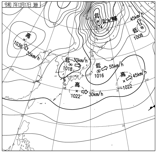
The wind remains strong up high and cold air is flowing in. 10-20cm snowfall and cornices and snowdrifts are slowly growing above 800m elevation. Cornices are still fragile, however the snowdrifts are stabilizing. Assessing all data, the avalanche risk is low in slopes below 1000m elevation. The snow in the trees is good, however you might end up bush crawling at the bottom if you miss the right path. Accessing the out of bounds from the resort is still closed. Please be patient. Do not cross boundary ropes. The groomer conditions are amazing. The lift lines are getting crowded, please don’t cut in lines. Westerly wind remains strong, beware of frostbites on your left cheek. Have a nice day.
Moiwa base 5am: -7℃, 15cm snowfall with snowdrift developments. Moiwa Mikaeri 800m: -10℃, W6.1m/s, cornices and snowdrifts developments. Hirafu Hanazono 800m: -10.2℃, NNW5.9m/s with 20m/s gusts, cornices and snowdrifts developments. Coastal data: Benkei cape WNW18m/s, Kamui capeSW17m/s, 1015hPa, 2.8m waves.
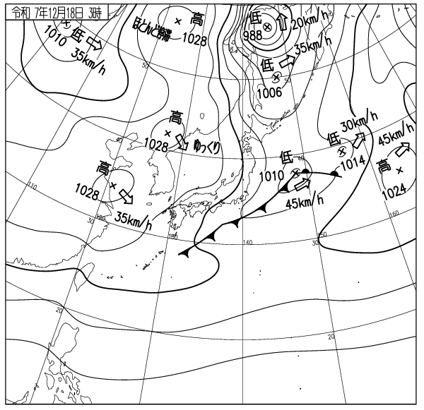
The wind is strong on the edge of the High Pressure system in the west and is making the wave height rise again. Westerly wind remains strong above 1000m and is developing cornices and snowdrifts. Although the average wind speed is around 6m/s, intermittent 20+m/s gusts are blowing. The formation of the slabs aren’t uniform. Wind-drift snow slabs in the leeward slopes above 800m have reached 100cm thickness and are yet to consolidate. They are still structurally unstable and the avalanche risk in leeward slopes under the ridge lines and cornices is high. Slides are likely to occur even if bamboo-grass are visible. Do not ride those slopes carelessly. Surface slab avalanches are highly likely to occur in slopes with heavy deposits of snowdrifts during storms until the snowpack consolidates and stabilizes. Most of the accidents occur in gorges and leeward slopes during storms. Keep this in mind as a common sense and you will avoid most accidents. Wind-affected snow crystals are firm and have a lot of friction. Still fun to ride, but the nose tends to dive down. Ride carefully and avoid ruining your season with a careless injury. The conditions will improve once the wind settles down. Do not push it too hard for now. Have a nice day.
Mountain base at 6am: -2℃, strongish wind, 5cm new snow, good visibility. Moiwa Mikaeri 800m: -5℃, WNW4.9m/s, large snowdrift development, good visibility. Hirafu Hanazono 800m: -4.8℃, NNW5.8m/s, trace new snow, snowdrift development. Coastal weather: Benkei cape NW15m/s, Kamui cape WSW12m/s, 1014hPa, 2.3m waves.
At elevations above 1000m, winds remain strong with significant snowdrift development. Winds have begun to decrease, and sea wave heights have dropped from 3.8m to 2.3m in the last 12 hours. However, observations and analysis of various data indicate a high avalanche risk on slopes with significant elevation differences, such as Backbowl sidewalls. Around 1100m elevation, snow cornice collapses or surface slab avalanches triggered by stimulation could occur. It’s still best not to ski there just yet. Bush is still dense, skiing off-piste is not yet suitable. Do not duck under the ropes. Be careful on steep south-facing slopes below 800m elevation, cliffs, and lift lines, where larger slab avalanches are likely to occur. Course conditions are improving daily. Watch for losing control and falling due to the narrow course width. Bamboo grass can scratch goggles and cheeks. Bamboo leaves are sharp. Beware. There is no such thing as safety in this sport. Don’t overestimate your knowledge or experience. Have a good day.
Moiwa base at 6am: 0℃, gusty winds, 30cm new snow in the last 6hrs, poor visibility. Moiwa Mikaeri 800m: -3℃, N5m/s, wind and snow, poor visibility. Hanazono 800m: -3℃, N10m/s, no new snow in the last 12hrs. Coastal data: Benkei cape NNE16m/s, Kamui cape ENE7m/s, 1002hPa, wave height 3m.
A 976hPa low pressure system passed bringing warm air from the south and 20cm – 40cm of heavy wet snow. Temperatures were high, and snow accumulated in the trees and on power lines. Above 800m, temperatures were below zero. Yesterday snowstorms from the north caused rapid cornice formation on southwest slopes and the avalanche risk was very high. A cold front moved in from the north in the afternoon with continuing the wind and snow. It’s best to stay within the ski resort today. Even within the resort, watch for avalanches on open slopes and below the lift line. Very heavy, wet snow has buried the bushes and shrubs off the runs, however skiing on the open, steep slopes under the cornices is very dangerous. Choose your route carefully. Watch out for crashing into trees, you won’t win that battle. Drive carefully on the road. Don’t rely too much on your tires. Once you start sliding, you won’t be able to stop. Watch out for snow falling from roofs. If you see children playing outside, be careful. Have a nice day.
Moiwa base at 6am: -5℃, light winds, no new snow, good visibility. Moiwa Mikaeri 800m: -9℃, E1.6m/s, no new snow. Hanazono 800m: -5.2℃, SSW4.4m/s, no new snow in the last 12hrs. Coastal data: Benkei cape SSE4m/s, Kamui cape SSE4m/s, 1019hPa, wave height 0.6m.
There has been no new snowfall and wind slabs above 800m have consolidated. The overall avalanche risk is low, however be careful as cornices around 1000m are prone to breakage. Due to the lack of snow the bamboo grass has not yet flattened, making only groomed runs suitable for skiing. Lets hope the next storm covers them up. Snowfall is expected to start in the afternoon from the front of an approaching low pressure system. Strong winds and snow will follow, bringing rapid cornice and snowdrift growth on the lee sides of ridges. The avalanche risk will increase. Pay close attention to future snowfall trends.
Most avalanche accidents occur during or immediately after snowstorms. When entering the mountains, please consider the risks of weather changes and plan your climb and skiing accordingly. Skiing off-piste is not yet permitted. Do not thoughtlessly duck under ropes. Guests must follow the ski resort rules and must not cut lift lines. Respect for all is required regardless of nationality. Have a fun, injury-free Sunday.
Moiwa base at 6am: -7℃, light wind, 20cm new snow over last 12 hours,light winds,good visibility. Hanazono 800m: -9.8℃, NNW5.0m/s, 20cm new snow. Moiwa Mikaeri 800m: -10℃, NNW1.7m/s, light snow. Coastal data: Benkei cape NW9m/s, Kamui CapeW8m/s, 1025hPa, 2.3m waves.
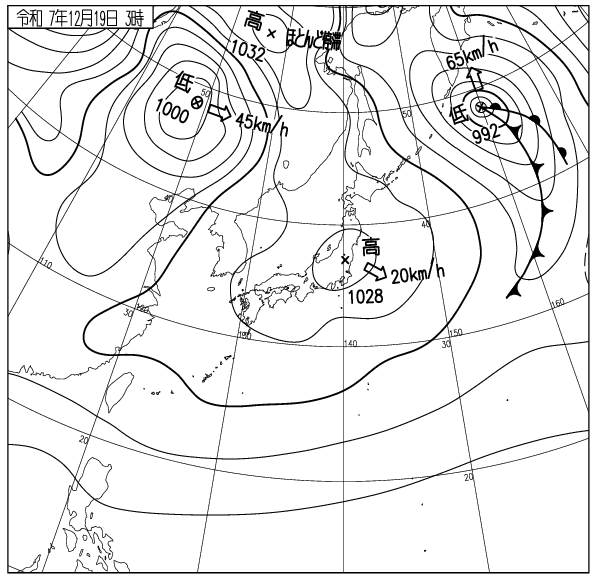
The isobar width is widening and ocean wave height and winds are both decreasing. Snowfall above 800m has reached 50cm in some places, with snow cornices forming in some areas. As the wind and snow calm down, the snow will change from broken crystals to crystalline snow, causing snow to slide. Based on observation data, the overall avalanche risk has decreased. On 40-degree leeward slopes above 800m there is still a possibility of surface avalanches with a 50cm fractured surface thickness in some places. Caution is required on ridge drops and gullies in mountainous areas. Skiing out of bounds from within the ski resort is still prohibited.
Follow the Niseko rules and listen to the advice of the ski patrol. There have been many injuries on the slopes. Be careful of reckless riding and falling. There is no safety in this sport. Have a nice day.
Mountain base at 6am: 0℃, light wind, 15cm new snow from midnight. Moiwa Mikaeri 800m: -3℃, NW0.8m/s, snowing, poor visibility. Hanazono 800m: -6.7℃, SSW2.3m/s. Coastal weather: Benkei cape S3m/s, Kamui cape N5m/s, 1013hPa, 1.4m waves.
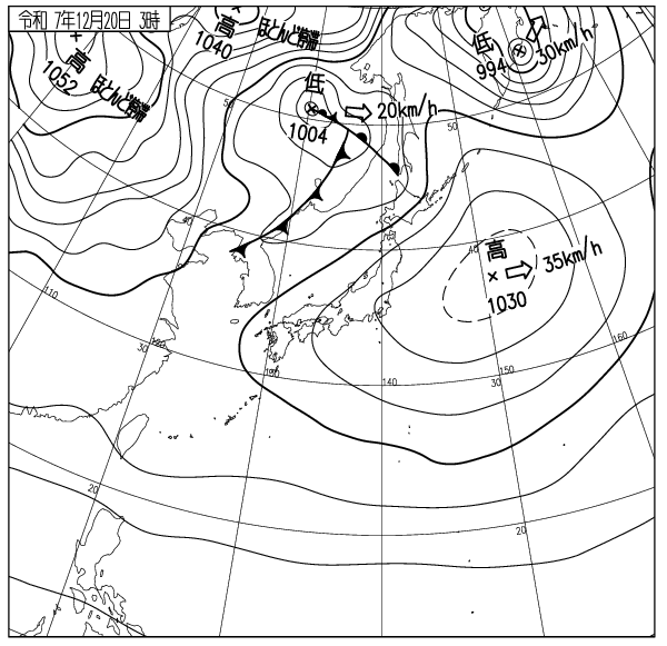
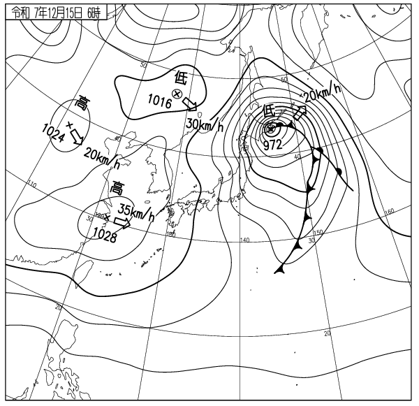
Strong pre-low-pressure snowfall from midnight. A low-pressure system of 1012 hPa is moving westward from the Sea of Japan, with southwesterly winds and snow intensifying this afternoon. Snow accumulation will increase, and snowdrifts are expected to develop rapidly above 800m elevation.
The current low-pressure snowfall is likely to trigger point avalanches on steep course-side cut slopes and cliff bands. Beware. Snow accumulation will increase rapidly before and after the front passes. Avalanche risk will rise sharply from this afternoon through tomorrow.
Wind-affected snowdrift slabs, developed intermittently by strong winds exceeding 15m/s, may appear hard and stable. However, the slab structure remains unstable until winds drop below 10 m/s and consolidation begins. Avalanches are likely to occur due to the increased weight of the slab (leeward snowdrifts) regardless of the snow stratigraphy. Do not over-rely on pit checks. Even if the cause is understood after an accident, the dead cannot be brought back.
Isobar widths will narrow going forward, with blizzards persisting. There is no safety in this sport. This is a ski resort; follow the rules. Patrols are always concerned for your safety.
Tomorrow’s avalanche report is suspended. Have a good day. When driving, apply brakes early to prevent a collision and running off the road.
出典 Source:気象庁 Japan Meteorological Agency (www.jma.go.jp/bosai/weather_map/)