• ニセコ雪崩情報第15号 Niseko Avalanche Info No.15

    モイワ山麓気温+5度降雪降雨なく融雪 モイワ800m+4.3度南西7.1m降雪なく視界良 見返り800m+1度南南西2.7m視界良 ヒラフ花園1000m0.4度東北東2.5m 花園800m+3.9度風向不明5.2m 日本海弁慶岬西北西10m 神威岬南西16m気圧1017hPa波高1.4m、

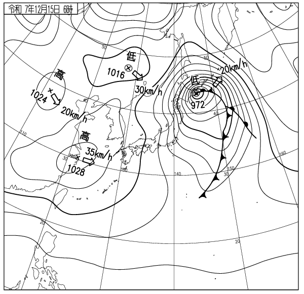
    沖縄フィリピン方面の暖気が日本海に入り気温上昇、前線の接近で上空の風は強い。標高1000m以下は+気温、場所によりゲレンデ圧雪困難。標高1000m以上はマイナス、標高800m以下はプラス気温のため雪質が異なる。南に面した急斜面、コース法面やリフト線下ではブロック崩壊の重い雪崩に注意。ロープをくぐりこれらの場所や立ち入り禁止区域に入ってはならない。暖気流入は明日もつづく。沢が増水してスノーブリッジが落ちやすくなっている。水は冷たい。屋根からの落雪が頻繁に起こっている。子供が遊んでいたら注意すること。光が弱くゲレンデの凹凸が見えない。暴走衝突に注意。今は待つしかない。状況に合わせた無理のない一日を。気象変化に注意。天気図は嘘をつかない。

    Moiwa base 5am: +5℃, no rain or snow, snowmelt. Mikaeri 800m: +4.3℃, SW7.1m/s, no new snow, good visibility. Hirafu 1000m: +0.4℃, ENE2.5m/s. Hanazono 800m: -3.9℃, 5.2m/s direction n/a. Coastal Data-  Benkei Cape NW10m/s, Kamui Cape SW16m/s, 1017hPa, 1.4m waves. 

    Above 1,000 m: temperatures are below freezing, while below 800 m temperatures are above freezing, resulting in differing snow conditions by elevation. Beware of heavy, block-type avalanches on south-facing steep slopes, steep sidewalls along runs, and under lift lines. Do not duck ropes to enter these areas or other restricted areas. The influx of warm air will continue tomorrow. Creek levels have risen and snow bridges are more likely to collapse. The water is cold. Snow is coming off the roofs, make sure children are playing in safe areas. The light is weak, making it difficult to see undulations in the slopes. Beware losing control. All we can do now is wait. Live a comfortable day suited to the conditions. Pay attention to changes in the weather. Weather maps don’t lie.

  • ニセコ雪崩情報第13号 Niseko Avalanche Info No.14

    モイワ山麓5時-5度風弱く降雪なし晴れ 見返り800m-9度西北西0.8m降雪5cm視界良 ヒラフ花園800m-5.3度北2.0m 日本海弁慶岬北西11m 神威岬西南西9m気圧1026hPa波高1.6m、

    高圧帯の中で海上波高風ともに低下、12時間の降雪わずか。各データ、観測から雪庇ふきだまりの発達は落ち着き雪崩リスクは低い。低温が続きゲレンデ状況は素晴らしく良いが雪が足りない。

    コース脇や山の笹や灌木はまったく埋まっておらずスキー場からのコース外滑走はできない。ニセコルールは過去の事故多発の経験を踏まえてやむを得ず設けられた。大勢が雪を楽しむスキー場には様々な人が来る。ルールはスキー場を利用する全ての人の安全のために設けられている。ニセコルールの尊重を。ゲレンデは混雑している。技術を過信して暴走してはならない。時に事故になる。

    本日モイワ800m地点の風速計設置が行われる。この情報は観測と客観的な数値データに基づき作られている。今日は悪くない。知識技術を過信せずに良い一日を。このスポーツに安全はない。

    Moiwa base 5am: -5℃, light winds, clear skies, no new snow. Mikaeri 800m: -9℃, WNW0.8m/s, 5cm new snow, good visibility. Hanazono 800m: -5.3℃, N2.0m/s. Coast Data-  Benkei Cape NW11m/s, Kamui Cape WSW9m/s, 1026hPa, 1.6m waves. 

    We are currently under a high pressure system, ocean waves and winds have decreased, and only light snowfall fell overnight. Data and observations indicate that cornice formation has settled and avalanche risk is low.  The low temperatures continue, making the slopes excellent, but there is a lack of snow.

    The bamboo grass and bushes  off-piste are still not buried, making off-piste skiing from the ski resort impossible. Niseko Rules were established out of necessity due to many accidents. A diverse range of people visit ski resorts to enjoy the snow. The Rules are in place to ensure the safety of all ski resort users. Please respect the Niseko Rules. The slopes are crowded. Don’t be overconfident, ride within your limits. Accidents can happen.

    Today an anemometer will be installed at Moiwa 800m. This report is based on observations and objective numerical data. Conditions are good today. Have fun and don’t be overconfident in your knowledge or skills. There is no safety in this sport.

  • ニセコ雪崩情報第13号 Niseko Avalanche Info No.13

    モイワ山麓6時気温-7度降雪10cmふきだまりなし 見返り800m-9度西北西4.7m降雪ふきだまり発達 ヒラフ花園1000m-13.4度 花園800m-10.5度北4.8mふきだまり発達 日本海弁慶岬北西14m 神威岬西南西11m気圧1019hPa波高2.6m、

    上空の風は依然強く引き続き寒気流入、降雪は10-20cmで標高800m以上雪庇ふきだまりがゆっくりと発達、観察から雪庇は割れやすいが、ふきだまりはスラブ化が弱まり安定し始めている。各データの評価から標高1000m以下の雪崩リスクは低い。森の中の雪は良いがルートを間違えると下部で藪漕ぎを強いられるので注意。スキー場からのコース外滑走はまだ出来ない。今しばらくの辛抱を。ロープをくぐってはならない。ゲレンデは素晴らしく良い。リフトが混雑し始めている。列を守ること。横入りをしてはならない。まだ西風が強い。左頬の凍傷に注意。良い一日を。

    Moiwa base 6am: -7℃, 10cm new snow, no snowdrifts. Mikaeri 800m: -9℃, WNW4.7m/s, snowing and snowdrifts developments. Hirafu Hanazono 1000m: -13.4℃. Hanazono 800m: -10.5℃, N4.8m/s, snowdrifts development. Sea of Japan Benkei cape NW14m/s, Kamui cape WSW11m/s, 1019hPa, 2.6m waves. 

    The wind remains strong up high and cold air is flowing in. 10-20cm snowfall and cornices and snowdrifts are slowly growing above 800m elevation. Cornices are still fragile, however the snowdrifts are stabilizing. Assessing all data, the avalanche risk is low in slopes below 1000m elevation. The snow in the trees is good, however you might end up bush crawling at the bottom if you miss the right path. Accessing the out of bounds from the resort is still closed. Please be patient. Do not cross boundary ropes. The groomer conditions are amazing. The lift lines are getting crowded, please don’t cut in lines. Westerly wind remains strong, beware of frostbites on your left cheek. Have a nice day.

    出典 Source:気象庁 JMA website (www.jma.go.jp/bosai/weather_map/)

  • ニセコ雪崩情報第12号 Niseko Avalanche Info No.12

    モイワ山麓5時-7度降雪15cmふきだまり発達 モイワ見返り800m-10度西6.1m雪庇ふきだまり発達 ヒラフ花園800m-10.2度北北西5.9m突風20m雪庇ふきだまり発達 日本海弁慶岬西北西18m 神威岬南西17m気圧1015hPa波高2.8m、

    西の高気圧側面の風強く海上波高は再び上昇、標高1000m以上では西寄りの風雪が強く雪庇ふきだまりが発達。平均風速は6m程度だが20m/sを越える突風が時折吹くためスラブ発達は一様ではない。標高800m以上風下側に堆積した風成雪スラブの厚さは100cm、圧密安定しておらず構造不安定が継続、稜線の風下側、雪庇斜面の雪崩リスクは高い。笹が見えていても破断する危険があるので安易に滑ってはならない。吹雪のふきだまり斜面は風が落ちて圧密安定(層序安定)するまで表層雪崩を起こしやすい。多くの事故は風雪時の谷や風下の側壁で起こっている。これを常識とすれば事故に遭わずにすむ。風の雪は結晶が硬く板が走らない。また面白いが板が刺さりやすい。今怪我をすればシーズンを棒に振る。風が落ちれば山は良くなる。無理は禁物、良い一日を。

    Moiwa base 5am: -7℃, 15cm snowfall with snowdrift developments. Moiwa Mikaeri 800m: -10℃, W6.1m/s, cornices and snowdrifts developments. Hirafu Hanazono 800m: -10.2℃, NNW5.9m/s with 20m/s gusts, cornices and snowdrifts developments. Coastal data: Benkei cape WNW18m/s, Kamui capeSW17m/s, 1015hPa, 2.8m waves. 

    The wind is strong on the edge of the High Pressure system in the west and is making the wave height rise again. Westerly wind remains strong above 1000m and is developing cornices and snowdrifts. Although the average wind speed is around 6m/s, intermittent 20+m/s gusts are blowing. The formation of the slabs aren’t uniform. Wind-drift snow slabs in the leeward slopes above 800m have reached 100cm thickness and are yet to consolidate. They are still structurally unstable and the avalanche risk in leeward slopes under the ridge lines and cornices is high. Slides are likely to occur even if bamboo-grass are visible. Do not ride those slopes carelessly. Surface slab avalanches are highly likely to occur in slopes with heavy deposits of snowdrifts during storms until the snowpack consolidates and stabilizes. Most of the accidents occur in gorges and leeward slopes during storms. Keep this in mind as a common sense and you will avoid most accidents. Wind-affected snow crystals are firm and have a lot of friction. Still fun to ride, but the nose tends to dive down. Ride carefully and avoid ruining your season with a careless injury. The conditions will improve once the wind settles down. Do not push it too hard for now. Have a nice day.

    出典 Source:気象庁 JMA website (www.jma.go.jp/bosai/weather_map/)

  • ニセコ雪崩情報第11号 Niseko Avalanche Info No.11

    モイワ山麓6時-2度風やや強く降雪5cm視界良 見返り800m-5度西北西4.9m降雪ふきだまり大視界良 ヒラフ花園800m-4.8度北北西5.8m降雪わずかふきだまり発達 日本海弁慶岬北西15m 神威岬西南西12m気圧1014hPa波高2.3m、

    標高1000m以上では依然風が強く雪庇ふきだまりが発達、風は落ちはじめ海上波高も12時間で3.8mから2.3mまで落ちているが、観測と各データの検討からバックボウル側壁など標高差の大きな斜面の雪崩リスクは高い。標高1100m付近では雪庇崩壊や滑走刺激による面発生表層雪崩が起きる可能性がある。まだ滑らないほうが良い。藪はまだ濃くコース外滑走は出来ない。ロープをくぐってはならない。標高800m以下の南側急斜面、崖やリフト線化ではやや規模の大きなブロック崩壊雪崩が起きやすいので注意。コース状況は日に日に良くなっている。コース幅が狭いので暴走転倒に注意。笹がゴーグルや頬を傷つける。笹の葉は鋭い。注意。このスポーツに安全はない。知識経験を過信せず今日も良い一日を。

    Mountain base at 6am: -2℃, strongish wind, 5cm new snow, good visibility. Moiwa Mikaeri 800m: -5℃, WNW4.9m/s, large snowdrift development, good visibility. Hirafu Hanazono 800m: -4.8℃, NNW5.8m/s, trace new snow, snowdrift development. Coastal weather: Benkei cape NW15m/s, Kamui cape WSW12m/s, 1014hPa, 2.3m waves.

    At elevations above 1000m, winds remain strong with significant snowdrift development. Winds have begun to decrease, and sea wave heights have dropped from 3.8m to 2.3m in the last 12 hours. However, observations and analysis of various data indicate a high avalanche risk on slopes with significant elevation differences, such as Backbowl sidewalls. Around 1100m elevation, snow cornice collapses or surface slab avalanches triggered by stimulation could occur. It’s still best not to ski there just yet. Bush is still dense, skiing off-piste is not yet suitable. Do not duck under the ropes. Be careful on steep south-facing slopes below 800m elevation, cliffs, and lift lines, where larger slab avalanches are likely to occur. Course conditions are improving daily. Watch for losing control and falling due to the narrow course width. Bamboo grass can scratch goggles and cheeks. Bamboo leaves are sharp. Beware. There is no such thing as safety in this sport. Don’t overestimate your knowledge or experience. Have a good day. 

  • ニセコ雪崩情報第7号 Niseko Avalanche Info No.10

    モイワ山麓0度降雪6時間湿雪30cm突風視界不良 見返り800m-3度北5m/s風雪視界不良 花園800m-3度北10.1m 日本海弁慶岬北北東16m 神威岬東北東7m気圧1002hPa波高3.0m、

    976hPaの低気圧が南の暖気とともに通過し多量の湿雪降雪20-40cm、気温高く樹林および電線着雪、標高800m以上はマイナス気温で北からの吹雪で南西側に雪庇ふきだまりが急激に発達、雪崩リスクは非常に高い。午後には北から寒気が入り引き続き風雪が続く。今日はスキー場から出ないほうが良い。場内でもコース法面、リフト線下の雪崩に注意。非常に重い湿った雪がコース外の藪や灌木を埋めているが、雪庇下の開けた急斜面を滑るのは危険、賢い滑走ルートの選択を。立ち木衝突に注意。木には勝てない。道路では慎重な運転を。タイヤを過信してはならない。滑り出したら止まらない。屋根からの落雪に注意。外で遊んでいる子供を見たら注意すること。良い一日を。

    Moiwa base at 6am: 0℃, gusty winds, 30cm new snow in the last 6hrs, poor visibility. Moiwa Mikaeri 800m: -3℃, N5m/s, wind and snow, poor visibility. Hanazono 800m: -3℃, N10m/s, no new snow in the last 12hrs. Coastal data: Benkei cape NNE16m/s, Kamui cape ENE7m/s, 1002hPa, wave height 3m.

    A 976hPa low pressure system passed bringing warm air from the south and 20cm – 40cm of heavy wet snow. Temperatures were high, and snow accumulated in the trees and on power lines. Above 800m, temperatures were below zero. Yesterday snowstorms from the north caused rapid cornice formation on southwest slopes and the avalanche risk was very high. A cold front moved in from the north in the afternoon with continuing the wind and snow. It’s best to stay within the ski resort today. Even within the resort, watch for avalanches on open slopes and below the lift line. Very heavy, wet snow has buried the bushes and shrubs off the runs, however skiing on the open, steep slopes under the cornices is very dangerous. Choose your route carefully. Watch out for crashing into trees, you won’t win that battle. Drive carefully on the road. Don’t rely too much on your tires. Once you start sliding, you won’t be able to stop. Watch out for snow falling from roofs. If you see children playing outside, be careful. Have a nice day.

  • ニセコ雪崩情報第7号 Niseko Avalanche Info No.9

    山麓6時-5度風よわく降雪なし視界良 見返り800m-9度東1.6m降雪なく視界良 花園800m-5.2度南南西4.4m降雪12時間なし 日本海弁慶岬南南東4m 神威岬南南東4m気圧1019hPa波高0.6m、

    新たな降雪はなく標高800m以上のウィンドスラブは時間の経過とともに圧密安定、全体の雪崩リスクは低いが標高1000m付近の雪庇は破断しやすいので注意。雪不足で笹が寝ておらず圧雪コース以外は滑走不適、次の嵐に期待。低気圧の接近で午後に低気圧前面降雪が始まりその後風雪が強まる。強い風雪は稜線風下側に雪庇やふきだまりを急成長させ雪崩リスクが上がる、今後の降雪推移に注意。

    雪崩事故の多くは吹雪の最中かその直後に起こっている。山に入る時は気象変化によるリスクを想像し、無理のない登山や滑走計画を。ゲレンデからのコース外滑走はまだ出来ない。安易にロープをくぐってはならない。ゲストはスキー場の規則を守らなければならず、またリフトの横入りをしてはならない。国籍に関係なく品位が問われる。怪我のない楽しい日曜日を。

    Moiwa base at 6am: -5℃, light winds, no new snow, good visibility. Moiwa Mikaeri 800m: -9℃, E1.6m/s, no new snow. Hanazono 800m: -5.2℃, SSW4.4m/s, no new snow in the last 12hrs. Coastal data: Benkei cape SSE4m/s, Kamui cape SSE4m/s, 1019hPa, wave height 0.6m.

    There has been no new snowfall and wind slabs above 800m have consolidated. The overall avalanche risk is low, however be careful as cornices around 1000m are prone to breakage. Due to the lack of snow the bamboo grass has not yet flattened, making only groomed runs suitable for skiing. Lets hope the next storm covers them up. Snowfall is expected to start in the afternoon from the front of an approaching low pressure system. Strong winds and snow will follow, bringing rapid cornice and snowdrift growth on the lee sides of ridges. The avalanche risk will increase. Pay close attention to future snowfall trends.

    Most avalanche accidents occur during or immediately after snowstorms. When entering the mountains, please consider the risks of weather changes and plan your climb and skiing accordingly. Skiing off-piste is not yet permitted. Do not thoughtlessly duck under ropes. Guests must follow the ski resort rules and must not cut lift lines. Respect for all is required regardless of nationality. Have a fun, injury-free Sunday.

  • ニセコ雪崩情報第7号 Niseko Avalanche Info No.8

    モイワ山麓-7度12時間降雪20cm風よわく視界良 ヒラフ花園800m-9.8度北北西5.0m降雪20cm 見返り800m-10度北北西1.7m小雪 日本海弁慶岬北西9m 神威岬西8m気圧1025hPa波高2.3m、

    等圧線幅ひろがり海上波高、風ともに低下、24時間の標高800m以上の降雪は場所により50cm、各所に雪庇ふきだまりが発達。風雪の落ち着きとともに雪は破砕結晶から結晶雪へと変化し、板が走る。観
    測各データの評価から全体の雪崩リスクは低下。標高800m以上の風下40度斜面では場所により破断面厚50cmの面発生表層雪崩の可能性が残る。山岳エリアの稜線落ち込みやガリーでは注意。

    スキー場からのコース外滑走はまだ出来ない。ニセコルールに従いパトロールの意見を聞くこと。コース内の怪我が多い。暴走転倒衝突に注意。このスポーツに安全はない。良い一日を。


    Moiwa base at 6am: -7℃, light wind, 20cm new snow over last 12 hours,light winds,good visibility. Hanazono 800m: -9.8℃, NNW5.0m/s, 20cm new snow. Moiwa Mikaeri 800m: -10℃, NNW1.7m/s, light snow. Coastal data: Benkei cape NW9m/s, Kamui CapeW8m/s, 1025hPa, 2.3m waves.

    The isobar width is widening and ocean wave height and winds are both decreasing. Snowfall above 800m has reached 50cm in some places, with snow cornices forming in some areas. As the wind and snow calm down, the snow will change from broken crystals to crystalline snow, causing snow to slide. Based on observation data, the overall avalanche risk has decreased. On 40-degree leeward slopes above 800m there is still a possibility of surface avalanches with a 50cm fractured surface thickness in some places. Caution is required on ridge drops and gullies in mountainous areas. Skiing out of bounds from within the ski resort is still prohibited.

    Follow the Niseko rules and listen to the advice of the ski patrol. There have been many injuries on the slopes. Be careful of reckless riding and falling. There is no safety in this sport. Have a nice day.

  • ニセコ雪崩情報第7号 Niseko Avalanche Info No.7

    山麓6時0度風弱く降雪未明から15cm増加 見返り800m-3度北西0.8m雪視界不良 日本海弁慶岬南3m 神威岬北5m気圧1013hPa波高1.4m 花園800m-6.7度南南西2.3m、

    未明から低気圧前面降雪強、日本海から1012hPaの低気圧が西進し午後には南西の風雪が強まる。積雪は増加し、標高800m以上では雪庇ふきだまりが急激に発達の見込み、現在の低気圧降雪は法面リフト線化崖斜面で点発生雪崩を起こしやすい。注意。前線通過前後の積雪の増加は急激、本日午後から明日にかけて雪崩リスクは急激に高まる。

    15m/s以上の強い風雪が断続して発達する風成雪スラブは一見硬く安定して見えるが、風が10m以下に落ちて圧密が始まるまでスラブ自体の構造が不安定。雪の層序に関係なくスラブ(風下ふきだまり)の自重増加で雪崩が起こりやすい。ピットチェックを過信してはならない。事故後に原因がわかっても死者は還らない。

    今後等圧線幅が狭まり吹雪が続く。このスポーツに安全はない。ここはスキー場なのでルールに従うこと。パトロールは皆さんの安全をいつも心配している。

    明日の雪崩情報は休む。良い一日を。車は衝突路外転落に注意。早めのブレーキを。

    Mountain base at 6am: 0℃, light wind, 15cm new snow from midnight. Moiwa Mikaeri 800m: -3℃, NW0.8m/s, snowing, poor visibility. Hanazono 800m: -6.7℃, SSW2.3m/s. Coastal weather: Benkei cape S3m/s, Kamui cape N5m/s, 1013hPa, 1.4m waves.

    Strong pre-low-pressure snowfall from midnight. A low-pressure system of 1012 hPa is moving westward from the Sea of Japan, with southwesterly winds and snow intensifying this afternoon. Snow accumulation will increase, and snowdrifts are expected to develop rapidly above 800m elevation.

    The current low-pressure snowfall is likely to trigger point avalanches on steep course-side cut slopes and cliff bands.  Beware. Snow accumulation will increase rapidly before and after the front passes. Avalanche risk will rise sharply from this afternoon through tomorrow.

    Wind-affected snowdrift slabs, developed intermittently by strong winds exceeding 15m/s, may appear hard and stable. However, the slab structure remains unstable until winds drop below 10 m/s and consolidation begins. Avalanches are likely to occur due to the increased weight of the slab (leeward snowdrifts) regardless of the snow stratigraphy. Do not over-rely on pit checks. Even if the cause is understood after an accident, the dead cannot be brought back.

    Isobar widths will narrow going forward, with blizzards persisting. There is no safety in this sport. This is a ski resort; follow the rules. Patrols are always concerned for your safety.

    Tomorrow’s avalanche report is suspended. Have a good day. When driving, apply brakes early to prevent a collision and running off the road.

    出典 Source:気象庁 Japan Meteorological Agency (www.jma.go.jp/bosai/weather_map/)

  • ニセコ雪崩情報第6号 Niseko Avalanche Info No.6

    山麓6時-6度風よわく降雪12時間降雪5cm積雪40cm小雪視界良 モイワ見返り800-8度北西2.0m 花園800m-8.3度北北西3.8m 日本海弁慶岬北西11m 神威岬西北西9m気圧1020hPa波高1.9m

    等圧線間隔拡がり海上、山ともに風が落ち始めている。標高800m以上では雪庇ふきだまりがゆっくりと成長、観察各データの評価から雪は安定し全体の雪崩リスクは低い。

    雪が少なくスキー場からのコース外滑走はかなり遅れる見込み。ゲレンデの未圧雪部分には新雪が10cm載っており場所により楽しめる。斜面の凹凸に注意。

    ロープをくぐりコース外を滑ってはならない。ニセコは滑走者の自由を尊重しその安全のためにニセコルールを運用している。ルールの尊重を。今晩からの雪に期待。良い一日を。

    Mountain base at 6am: -6℃, light wind, 5cm snowfall in 12hrs, 40cm accumulated snow, light snow, good visibility. Moiwa Mikaeri 800m: -8℃, NW2.0m/s. Hanazono 800m: -8.3℃, NNW3.8m/s. Coastal weather: Benkei cape NW11m/s, Kamui cape WNW9m/s, 1020hPa, 1.9m waves.

    Isobars are widely spaced, and the wind is starting to subside over both sea and mountains. Cornice and snowdrifts are slowly developing on the slopes over 800m elevation. From the data and observations, snow is stabilised, and the overall avalanche risk is low. 

    ​Due to the limited snowfall, out-of-bounds skiing from ski resorts is expected to be delayed. 10cm of new snow on some off-piste areas in ski resorts can be fun. Beware of the uneven terrain.

    Do not duck ropes to ski out of bounds. Niseko respects your freedom to ski out of bounds and runs Niseko Rules for your safety. Please respect the rules. Looking forward to tonight’s snow. Have a good day.

    出典 Source:気象庁 Japan Meteorological Agency (www.jma.go.jp/bosai/weather_map/)

ニセコ雪崩情報 Niseko Avalanche Info

©︎Niseko Avalanche Insitute