• ニセコ雪崩情報第7号 Niseko Avalanche Info No.8

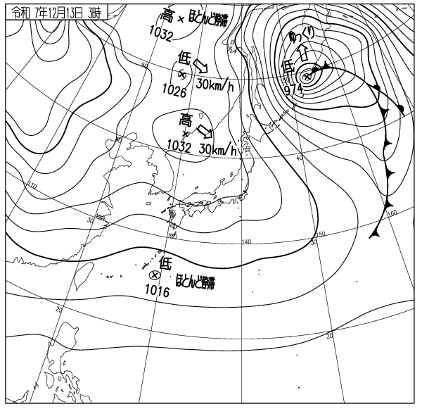
    モイワ山麓-7度12時間降雪20cm風よわく視界良 ヒラフ花園800m-9.8度北北西5.0m降雪20cm 見返り800m-10度北北西1.7m小雪 日本海弁慶岬北西9m 神威岬西8m気圧1025hPa波高2.3m、

    等圧線幅ひろがり海上波高、風ともに低下、24時間の標高800m以上の降雪は場所により50cm、各所に雪庇ふきだまりが発達。風雪の落ち着きとともに雪は破砕結晶から結晶雪へと変化し、板が走る。観
    測各データの評価から全体の雪崩リスクは低下。標高800m以上の風下40度斜面では場所により破断面厚50cmの面発生表層雪崩の可能性が残る。山岳エリアの稜線落ち込みやガリーでは注意。

    スキー場からのコース外滑走はまだ出来ない。ニセコルールに従いパトロールの意見を聞くこと。コース内の怪我が多い。暴走転倒衝突に注意。このスポーツに安全はない。良い一日を。


    Moiwa base at 6am: -7℃, light wind, 20cm new snow over last 12 hours,light winds,good visibility. Hanazono 800m: -9.8℃, NNW5.0m/s, 20cm new snow. Moiwa Mikaeri 800m: -10℃, NNW1.7m/s, light snow. Coastal data: Benkei cape NW9m/s, Kamui CapeW8m/s, 1025hPa, 2.3m waves.

    The isobar width is widening and ocean wave height and winds are both decreasing. Snowfall above 800m has reached 50cm in some places, with snow cornices forming in some areas. As the wind and snow calm down, the snow will change from broken crystals to crystalline snow, causing snow to slide. Based on observation data, the overall avalanche risk has decreased. On 40-degree leeward slopes above 800m there is still a possibility of surface avalanches with a 50cm fractured surface thickness in some places. Caution is required on ridge drops and gullies in mountainous areas. Skiing out of bounds from within the ski resort is still prohibited.

    Follow the Niseko rules and listen to the advice of the ski patrol. There have been many injuries on the slopes. Be careful of reckless riding and falling. There is no safety in this sport. Have a nice day.

  • ニセコ雪崩情報第7号 Niseko Avalanche Info No.7

    山麓6時0度風弱く降雪未明から15cm増加 見返り800m-3度北西0.8m雪視界不良 日本海弁慶岬南3m 神威岬北5m気圧1013hPa波高1.4m 花園800m-6.7度南南西2.3m、

    未明から低気圧前面降雪強、日本海から1012hPaの低気圧が西進し午後には南西の風雪が強まる。積雪は増加し、標高800m以上では雪庇ふきだまりが急激に発達の見込み、現在の低気圧降雪は法面リフト線化崖斜面で点発生雪崩を起こしやすい。注意。前線通過前後の積雪の増加は急激、本日午後から明日にかけて雪崩リスクは急激に高まる。

    15m/s以上の強い風雪が断続して発達する風成雪スラブは一見硬く安定して見えるが、風が10m以下に落ちて圧密が始まるまでスラブ自体の構造が不安定。雪の層序に関係なくスラブ(風下ふきだまり)の自重増加で雪崩が起こりやすい。ピットチェックを過信してはならない。事故後に原因がわかっても死者は還らない。

    今後等圧線幅が狭まり吹雪が続く。このスポーツに安全はない。ここはスキー場なのでルールに従うこと。パトロールは皆さんの安全をいつも心配している。

    明日の雪崩情報は休む。良い一日を。車は衝突路外転落に注意。早めのブレーキを。

    Mountain base at 6am: 0℃, light wind, 15cm new snow from midnight. Moiwa Mikaeri 800m: -3℃, NW0.8m/s, snowing, poor visibility. Hanazono 800m: -6.7℃, SSW2.3m/s. Coastal weather: Benkei cape S3m/s, Kamui cape N5m/s, 1013hPa, 1.4m waves.

    Strong pre-low-pressure snowfall from midnight. A low-pressure system of 1012 hPa is moving westward from the Sea of Japan, with southwesterly winds and snow intensifying this afternoon. Snow accumulation will increase, and snowdrifts are expected to develop rapidly above 800m elevation.

    The current low-pressure snowfall is likely to trigger point avalanches on steep course-side cut slopes and cliff bands.  Beware. Snow accumulation will increase rapidly before and after the front passes. Avalanche risk will rise sharply from this afternoon through tomorrow.

    Wind-affected snowdrift slabs, developed intermittently by strong winds exceeding 15m/s, may appear hard and stable. However, the slab structure remains unstable until winds drop below 10 m/s and consolidation begins. Avalanches are likely to occur due to the increased weight of the slab (leeward snowdrifts) regardless of the snow stratigraphy. Do not over-rely on pit checks. Even if the cause is understood after an accident, the dead cannot be brought back.

    Isobar widths will narrow going forward, with blizzards persisting. There is no safety in this sport. This is a ski resort; follow the rules. Patrols are always concerned for your safety.

    Tomorrow’s avalanche report is suspended. Have a good day. When driving, apply brakes early to prevent a collision and running off the road.

    出典 Source:気象庁 Japan Meteorological Agency (www.jma.go.jp/bosai/weather_map/)

  • ニセコ雪崩情報第6号 Niseko Avalanche Info No.6

    山麓6時-6度風よわく降雪12時間降雪5cm積雪40cm小雪視界良 モイワ見返り800-8度北西2.0m 花園800m-8.3度北北西3.8m 日本海弁慶岬北西11m 神威岬西北西9m気圧1020hPa波高1.9m

    等圧線間隔拡がり海上、山ともに風が落ち始めている。標高800m以上では雪庇ふきだまりがゆっくりと成長、観察各データの評価から雪は安定し全体の雪崩リスクは低い。

    雪が少なくスキー場からのコース外滑走はかなり遅れる見込み。ゲレンデの未圧雪部分には新雪が10cm載っており場所により楽しめる。斜面の凹凸に注意。

    ロープをくぐりコース外を滑ってはならない。ニセコは滑走者の自由を尊重しその安全のためにニセコルールを運用している。ルールの尊重を。今晩からの雪に期待。良い一日を。

    Mountain base at 6am: -6℃, light wind, 5cm snowfall in 12hrs, 40cm accumulated snow, light snow, good visibility. Moiwa Mikaeri 800m: -8℃, NW2.0m/s. Hanazono 800m: -8.3℃, NNW3.8m/s. Coastal weather: Benkei cape NW11m/s, Kamui cape WNW9m/s, 1020hPa, 1.9m waves.

    Isobars are widely spaced, and the wind is starting to subside over both sea and mountains. Cornice and snowdrifts are slowly developing on the slopes over 800m elevation. From the data and observations, snow is stabilised, and the overall avalanche risk is low. 

    ​Due to the limited snowfall, out-of-bounds skiing from ski resorts is expected to be delayed. 10cm of new snow on some off-piste areas in ski resorts can be fun. Beware of the uneven terrain.

    Do not duck ropes to ski out of bounds. Niseko respects your freedom to ski out of bounds and runs Niseko Rules for your safety. Please respect the rules. Looking forward to tonight’s snow. Have a good day.

    出典 Source:気象庁 Japan Meteorological Agency (www.jma.go.jp/bosai/weather_map/)

  • ニセコ雪崩情報第5号 Niseko Avalanche Info No.5

    山麓-1度西南西2m降雪12時間10cm24時間20cm モイワ見返り-7度西北西3.8m視界不良 海上弁慶岬北西16m 神威岬西12m気圧1018hPa波高2.1m 花園800m-6.2度北北西6.3m積雪データなし


    夜半東北地方地震震度7津波最大40cm 気圧配置冬型

    標高800m以上で20m/s以下の風雪、量は少ないが稜線風下側に雪庇ふきだまりが発達、雪は昨日の低気圧降雪20cmとともに雪板化(スラブ化)しており開けた急斜面で浅い面発生雪崩が起こりやすい。

    ゲレンデは薄く新雪に覆われているが下部コース以外は滑走不適、今怪我をすればシーズンを棒に振る。気象推移、凍傷に注意、良い一日を。


    Mountain base: -1℃, WSW2m/s, 10cm snowfall in the last 12hrs, 20cm in 24hrs. Moiwa Mikaeri 800m: -7℃, WNW3.8m/s, bad visibility. Hanazono 800m: -6.2℃, NNW6.3m/s. Coastal weather: Benkei cape NW16m/s, Kamui cape W12m/s, 1018hPa, 2.1m waves.

    Earthquake in Tohoku area at midnight: Intensity 7, Tsunami Peak 40cm. Winter-type pressure pattern.


    Snowstorms with winds below 20m/s over 800m elevation. Though snowfall amounts are low, snowdrifts have developed on the leeward side of ridgelines. Snow has formed a slab layer with yesterday’s 20cm of low-pressure snowfall, making shallow surface avalanches likely on open steep slopes.


    Ski slopes are covered with a thin layer of fresh snow, but skiing is unsuitable except on lower courses. Getting injured now could ruin your entire season. Monitor weather changes and beware of frostbite. Have a good day.

    出典 Source:気象庁 JMA website (www.jma.go.jp/bosai/weather_map/)

  • ニセコ雪崩情報第4号 Niseko Avalanche Info No.4

    山麓6時+2度積雪30cm  モイワ見返り800m-7度南東1.5m降雪視界不良 花園800m-1.4度北3.0m夜半0時北東23m/s突風 日本海弁慶岬北北西5m 神威岬南西7m気圧1012hPa波高1.1m、

    未明まで降雪なし、午前6時から低気圧前面降雪、午後には前線通過で山は荒れ模様の見込み。雪は依然少なく圧雪されたコース以外は滑走不能、待つしかない。

    寒暖差が大きいため地表付近のシモザラメ化が進んでいる。この層は初冬のニセコに稀に見られ、全層雪崩の原因となる。コース法面や笹地表の急斜面では注意。

    事故が最も多い面発生表層雪崩は吹雪など悪天候時に起こりやすい。風雪時に風下側のふきだまり斜面を滑ってはならない。スラブが弱線破断して雪崩を起こす。良い一日を。

    Mountain base 6am: +2℃, 30cm snowpack. Moiwa Mikaeri 800m: -7℃, SE1.5m/s, snowing and bad visibility. Hanazono 800m: -1.4℃, N3.0m/s (NE23m/s gusts at midnight). Coastal weather: Benkei cape NNW5m/s, Kamui cape SW7m/s, 1012hPa, 1.1m waves. 

    No snowfall until predawn, but started to fall around 6am as the next Low Pressure approaches. The Cold Front will pass in the afternoon and the weather is forecasted to deteriorate. The snowpack remains shallow and the slopes are not suitable for skiing except the groomed runs. Patience is required. 

    Depth hoar is developing with the recent large temperature swing. This is quite unusual for early Winter in Niseko and can potentially be a trigger layer for glide avalanches. Caution is required in steep slopes on the course-sides and/or with bamboo-grass. Surface slab avalanches, which are the cause of most accidents, mostly occur during snowstorms or other bad weather conditions. Leeward slopes with heavy snowdrift deposits should be avoided during strong winds and snowfalls. Weak bonding within the newly formed slabs can easily fail and trigger a slide. Have a nice day. 

    出典 Source:気象庁 Japan Meteorological Agency (www.jma.go.jp/bosai/weather_map/)

  • ニセコ雪崩情報第3号 Niseko Avalanche Info No.3

    モイワ山麓風よわく+4度降雪なし曇り視程800m以下 日本海弁慶岬西北西8m 神威岬南西16m気圧1012hPa波高1.5m 花園+0度北3.2m濃霧視界不良降雪わずか 見返り800m-3度南南東0.6m降雪わずか濃霧視界不良、

    日本海を暖気が北上、標高1000m以下はプラス気温と濃霧、1000m以上は南西の風がやや強い。夜半の弱い降雪が雪面の凹凸部に浅く堆積、観測から雪崩リスクは低いがコース法面、崖斜面では浅い雪崩に注意。光線が弱く斜面の凹凸が見づらい。暴走転倒衝突に注意。今怪我をすればシーズンを棒に振る。ゲレンデは混んでいる。他者への配慮を。雪はそのうちに降る。良い一日を。

    Mountain base: light wind, +4℃, no new snowfall, overcast, visibility less than 800m. Coastal weather: Benkei cape WNW8m/s, Kamui cape SW16m/s, 1012hPa, 1.5m waves. Hanazono: 0℃, N3.2m/s, thick fog, poor visibility and light dusting. Mikaeri 800m: -3℃, SSE0.6m/s, light dusting, thick fog and bad visibility.

    Warm air is flowing north from the Sea of Japan. The temperature is above freezing up to 1000m elevation. Thick fog is lying up high. Moderate SW wind is blowing above 1000m. A little bit of snow fell overnight and shallowly filled in the gap of the surface. Avalanche risk is low, however still to be considered on the steep course-side cut slopes and cliffbands. The light is weak and the terrain undulations are hard to see. Beware of overspeeding, falls and collisions. One injury now can ruin your season. The slopes are crowded, please mind of others. The snow will eventually come. Have a nice day.

    出典:気象庁HP (www.jma.go.jp/bosai/weather_map/)

  • ニセコ雪崩情報第2号 Niseko Avalanche Info No.2

    山麓+2度降雪なく曇り積雪30cm 海上弁慶岬西北西14m 神威岬南西17m ニセコ花園1000m南南東12.3m気温-3.6度 12月6日層を記録。

    上空の風は強いが雪は期待したほど入っていない。次の低気圧待ち。標高1000m以上は風が強く場所により雪庇ふきだまりが発達、

    雪庇は崩壊しやすく稜線直下では40cm以下の浅い面発生表層雪崩が起こりやすい。 

    ゲレンデの地形変化に注意、光がなく凹凸が見えづらい。暴走衝突に注意。今怪我をすればシーズンを棒に振る。良い一日を。

    Mountain base +2℃, cloudy with no new snowfall, snowpack 30cm. Coastal weather: Benkei cape WNW14m/s, Kamui cape SW17m/s. Niseko Hanazono 1000m: SSE12.3m/s, -3.6℃. Dec 6th layer recorded. 

    The upper sky wind is blowing strong, however it hasn’t brought much snow as anticipated. We’ll have to wait for the next Low-pressure to come. The wind speed remains high above 1000m elevation, developing cornices and snowdrifts in some areas. These cornices are highly likely to break. Surface slab avalanches of up to 40cm thickness are to be expected in leeward slopes just under ridgelines. 

    Beware of the groomers’ terrain undulation. The light is flat and the unevenness is hard to see. Be careful not to overspeed and crash. One injury now can ruin your whole season. Have a nice day.

  • ニセコ雪崩情報第1号 Niseko Avalanche Info No.1

    山麓6時 -7度 降雪12時間20cm 北西5m 弱い風雪。日本海弁慶岬北北西17m神威岬西南西14m1005hPa波高1.8m。

    西高東低冬型の気圧配置で寒気流入、標高800m以上は10m/sを越える西寄りの吹雪、雪庇ふきだまりが発達、標高900m以上の南斜面では、解けずに残った地表上の15cmがシモザラメ化している。笹の30度斜面では急激な積雪増で雪崩れやすくなるので注意。真冬でも全層雪崩は起こる。雪はまだ足りない。今無理をすればシーズンを棒にふる。知識技術を過信せず常に用心を。

    全ての観測測器が稼働するまでしばらくかかる。情報は不定期に出される。良いシーズンを。

    Mountain base 6am: -7℃, 12h snowfall 20cm, NW5m/s, light snow and wind. Coastal data: Benkei cape NNW17m/s, Kamui cape WSW14m/s, 1005hPa, 1.8m waves. 

    Wintery pressure distribution with a Low in the East and High in the West is making cold air flowing into Japan. Stormy weather with Northwesterly 10+m/s wind above 800m elevation. Snowdrifts are developing rapidly. The old snow that persisted in south facing slopes above 900m are forming a 15cm layer of granular snow (depth hoar) on top of the ground. Avalanches are likely to occur in 30degree slopes with bamboo-grass with the rapid growth of new snowpack. Glide avalanches can occur even in the heart of Winter. 

    The snowpack is still very shallow, don’t push it too hard and waste your season. Stay vigilant and do not overestimate your knowledge and skill. 

    It will take some more time to have all our observation instruments running. The report will be issued irregularly for some time. Have a great season. 

  • ニセコ雪崩情報第110号 Niseko Avalanche Info No.110

    4月1日からのヒラフスキー場営業休止に伴い、ヒラフ3番ゲートからの山頂登頂はできません。山頂へはアンヌプリ2番ゲートから登ってください。山頂からヒラフ側への滑走は、ヒラフトップリフト周辺での重機を使った作業中のため、危険です。絶対にヒラフ側へは滑り込まないようにお願いします。ビレッジのトップリフトを利用されるみなさんも、山頂へはアンヌプリ2番ゲートを利用してください。ゲートの開閉はアンヌプリパトロールの判断で行います。鉱山の沢と大沢の標高1100m付近からの全層雪崩の危険が高まっています。滑走に注意してください。

    Due to the Hirafu ski resort closure on 1 April, Hirafu Gate 3 will be closed for the season. Please use Annupuri Gate 2 for the peak access. Riding into the Hirafu area is prohibited as heavy machinery operates around the Hirafu top lift. Very dangerous. For those who use the Niseko Village top lift, please use the Annupuri Gate 2 to reach the summit. Annupuri patrols will decide the gate’s opening. The risk of full-depth avalanche is increasing on the slopes above 1100m elevation in Kozan no Sawa and Osawa. Be prudent.
  • ニセコ雪崩情報第109号 Niseko Avalanche Info No.109

    山麓-6度降雪10cm視界良 モイワ800m-8.6度北西10.3m雪庇ふきだまり発達 アンヌプリ1100m-10.7度西北西11.7m ヒラフ花園-10.1度南南東4.3m降雪5cm視界良 日本海弁慶岬北西16m 神威岬西13m気圧1024hPa波高1.5m、

    寒気が入り冬に逆戻り。標高800m以上、尾根の風下には15-30cmのふきだまりが入りスラブ化。各データの評価から午前中は雪庇斜面で破断面40cm以内の面発生表層雪崩が起こる可能性がある。風が弱まれば山頂ゲートは開けられる見込み。パトロールの判断を尊重すること。雪は良いが底当たりする。また大沢、鉱山の沢、東尾根、モイワボウルなどの開けた急斜面では引き続き全層雪崩の危険が続いている。特に鉱山の沢側壁、西尾根標高1100m付近の亀裂が拡がり始めている。近寄らないほうが良い。コース外や山では常に正しい判断が求められている。ビーコンは義務ではないが持つことを勧める。あれば自分と仲間の命を救う可能性が高まる。今シーズンの雪崩情報を終了する。このスポーツに安全はない。毎日の事故防止に取り組んだ各スキー場パトロールと圧雪車オペレーターに感謝したい。

    Moiwa Mountain base -6℃,10cm new snow, good visibility. Moiwa 800m: -8.6℃, NW10.3m/s, cornice and snowdrift development. Annupuri 1100m: -10.7℃, WNW11.7m/s. Hirafu Hanazono 1000m: -10.1℃,  SSE4.3m/s, 5cm new snow, good visibility. Coastal data: Benkei Cape NW16m/s, Kamui Cape W13m/s, 1024hPa, wave 1.5m. 

    Cold air has come in and winter has returned. Above 800m, 15-30cm snowdrifts have formed slabs on the lee side of ridges. From data evaluation, there is the possibility of up to 40cm surface avalanches on cornice slopes this morning. If the wind drops, peak gates are expected to open. Please respect the patrol’s judgment. The snow is good, but you will still hit the bottom. The risk of full-depth avalanches continues on the open, steep slopes of Osawa, Kozan no Sawa, Higashi-one, Moiwa Bowl, etc. In particular, cracks are beginning to widen on Kozan no Sawa sidewalls and the West Ridge around 1,100m. Avoid going near them. Always use good judgment off the trails and in the mountains. Although it is not mandatory, carrying a beacon is recommended. Having one will increase the chances of saving your life and the lives of your friends. This is the last avalanche information for this season. There is no safety in this sport. We would like to thank the resort ski resort patrols and snow groomer operators who work hard every day to prevent accidents.

ニセコ雪崩情報 Niseko Avalanche Info

©︎Niseko Avalanche Insitute